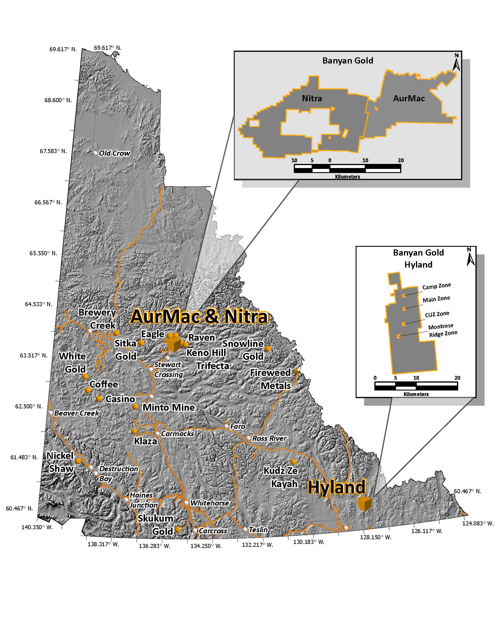
 The Hyland Gold Project is 100% owned, subject to certain royalties, and is located in the Watson Lake Mining District in the southeast Yukon, approximately 74 kilometres northeast from the town of Watson Lake within the traditional territory of the Kaska Dena Nation (Liard First Nation). The Project consists of 927 active Yukon registered quartz mineral claims totalling over 18,620 hectares in area.
On October 27, 2025, Banyan released an updated National Instrument 43-101 Technical Report (NI-43-101) Indicated Mineral Resource of 337,000 ounces (“oz”) of gold (“Au”) and 2.63 million (“M”) oz of silver (“Ag”) (11.3 M tonnes of ore at 0.93 g/t Au and 7.27 g/t Ag), and an Inferred Mineral Resource of 118,000 oz of Au and 0.86M oz Ag (3.9 M tonnes of ore at 0.95 g/t Au and 6.94 g/t Ag) (as defined in the Canadian Institute of Mining, Metallurgy and Petroleum (“CIM”) Definition Standards for Mineral Resources & Mineral Reserves incorporated by reference into NI 43-101).
The updated Mineral Resource Estimate (“MRE”) is summarized below in Table 1. The Hyland Project pit-constrained MRE is contained in a single near/on-surface deposit.
Table 1: Pit-Constrained Indicated and Inferred Mineral Resources – Hyland Project
|
|
|
|
|
|
|||
|
|
|
|
|
|
|
||
|
|
|||||||
|
|
|
|
|
|
|
|
|
|
|
|||||||
|
|
|
|
|
|
|
|
|
Hyland Gold Project Main Zone Mineral Resource Estimate Notes:
Mineral exploration in the Hyland Gold project area began in the 1800s, with the discovery of the McMillan zinc-lead-silver deposit, 5 kilometres west of the property. Exploration in the area for potential gold mineralization began in 1981 by Archer Cathro on behalf of Kidd Creek Mines Ltd. with the discovery of 450 metre long anomalous gold-arsenic-bismuth soil geochemistry. The deposit was the subject of intermittent exploration from the 1980s to mid-2000s. In 2013, the prospecting led to the discovery of the Montrose Ridge Zone, the southern extension of the Cuz Zone.
The Hyland Gold project is interpreted as sediment-hosted, structurally controlled, Carlin-style gold mineralization. Gold mineralization is hosted within Precambrian sediments of the Selwyn basin that hosts numerous other Carlin-style occurrences elsewhere in the Yukon. The Hyland Gold project consists of the Main Zone, Camp Zone, Cuz Zone, and Montrose Ridge Zone that extends over 11 kilometres. Mineralization on the Hyland Gold project is controlled by regional-scale, N-trending faults that extend beyond the current zones; therefore, the deposit remains open to exploration to both north and south.
LOCATION AND INFRASTURCTURE
The Hyland Gold Project is located in the Watson Lake Mining District in southeast Yukon, Canada. The Property is situated approximately 74 kilometres northeast from the town of Watson Lake and it is centered at latitude 60° 30’ 28” N, and longitude 127° 50’ 56”W.
The Project is accessible by float plane from Watson Lake to Quartz Lake, or by helicopter from Watson Lake. A 40 km long winter road provides access to the property from the government-maintained Coal River Road. The winter trail connects to a network of drill roads that leads down into the exploration camp on Quartz Lake.
GEOLOGY
The Hyland Gold Project is located in the southeastern Selwyn Basin underlain by the Yusezyu, Narchilla, and Vampire Formations of the Precambrian Hyland Group. The Selwyn Basin is a continental margin that formed from passive margin sedimentation and it is characterized by a thick accumulation of rift-related classic rocks with deep-water offshelf sediments. The Hyland Group, which is currently recognized as the main host of the Hyland deposit is subdivided into three main formations: 1. Neoproterozoic Yusezyu Formation; 2. Neoproterozoic to Lower Cambrian Narchilla Formation, and 3. Neoproterozoic to Lower Cambrian Vampire Formation. The Hyland Gold Project is underlain by an interbedded sequence of quartzite, limestone, and phyllite that thought to represent the transition zone between the Yusezyu and Vampire Formations of the Hyland Group.
The interbedded sequence appears to be folded about a north-south trending anticline overlain by massive limestone to the east and to the west. A north-south trending structural trend referred to as the Quartz Lake Lineament (QLL) coincides with the anticline axis and it appears to be the major control of mineralization. East-west trending, cross-cutting faults are also mineralized and are secondary control on gold mineralization.
There are two styles of hydrothermal alteration related to gold mineralization that occurs on the Hyland Gold Property. Pervasive, arsenopyrite – pyrite - silica ± tourmaline alteration is common within the mineralized intervals and it locally eradicates primary sedimentary features. White quartz veins immediately adjacent to the mineralized intervals are generally barren but are interpreted as part of the same alteration package. Sulphide minerals are disseminated or occur as narrow, dismembered veinlets throughout the altered intervals. The second type of alteration consists of patchy to pervasive, fine - grained, iron carbonate with local quartz – carbonate - titanite veins cross - cutting earlier quartz - sulphide veins; therefore, it is interpreted to post-date the earlier arsenopyrite - pyrite-silica ± tourmaline alteration.
MINERALIZATION
Primary gold mineralization is oxidized to varying depths and it generally occurs within or peripheral to the north - northeast trending Quartz Lake Lineament, notably where it is cross - cut by east - west trending faults. Gold mineralization; therefore, is strongly correlated with fault gouge and heavily fractured, brittle, quartz - flooded host rocks with anomalous arsenic and bismuth. Oxidized to partially oxidized iron carbonate, semi – massive to massive sulphide, and manto - like siderite bodies near or peripheral to the QLL are also mineralized and are interpreted to represent the deeper parts of the system. Primary mineralization compromises of pyrite, arsenopyrite ± chalcopyrite and minor sphalerite, tetrahedrite, pyrrhotite, and bismuthinite. The preferred host for high - grade gold mineralization (>5 g/t gold) is characterized by scorodite - stained, grey quartz veins with abundant cavities after sulphide minerals with lesser mineralization in brecciated jasperoids or quartz - flooded horizons surrounded by sericite - clay altered intervals. Native gold grains typically occur at pyrite - arsenopyrite grain boundaries or as inclusions within pyrite, and are locally also associated with bismuthinite. In summary, gold mineralization occurs in four different forms:
(1) Breccia zones, veins, and auriferous sulphide disseminations in silicified phyllites.
(2) North trending fault zones containing pods of semi - massive to massive pyrrhotite ± pyrite.
(3) Manto - like siderite replacement bodies up to 40 metres thick along the Quartz Lake Lineament containing minor pyrite, pyrrhotite, and arsenopyrite.
(4) Narrow quartz veins containing erratic pods of massive jamesonite that assayed up to 3.4 g/t gold, 41 % Pb, and 154.3 g/t silver.
DEPOSIT-TYPE
The Hyland Gold Project is interpreted as a distal intrusion - related, sediment - hosted, structurally controlled, gold mineralized target. Distal, sediment - hosted deposits are identified by characteristic hydrothermal alteration assemblages consisting jasperoidal silicification, argillization, and decalcification of carbonate - bearing lithologies. Controls on mineralization include association with fold hinges, reactivated faults, and manto - like shapes to mineralized host-rocks.
Similar deposit - types with direct and indirect magmatic association elsewhere in the Selwyn Basin include the Tiger deposit of ATAC Resources Ltd., where mineralization consists of sediment - hosted carbonate replacement developed within a Silurian to Devonian, shallow water limestone unit adjacent to a major regional - scale, crustal fault. The best analogy to the Hyland Gold Project is suggested to be the Marigold Mine in north - central Nevada, USA. Gold mineralization at the Marigold Mine is hosted by a Paleozoic, passive margin sedimentary sequence and controlled by a series of north - trending faults cross - cut by second order north - west and north - east trending faults.